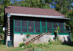
Garrison Creek is located on the Natchez Trace Parkway at milepost 427.6.

Hiking Trail northern trailhead of 24 mile-long Highland Rim Trail (Natchez Trace National Scenic Trail) + 2 mile loop trail
Picnic Area 5 picnic tables, 3 grills
Top 30 Natchez Trace Favorite Site Restrooms
Garrison Creek - Natchez Trace Parkway
Garrison Creek Tennessee

Photo Taken: October 19
Photo Credit: Trent Rosenbloom
Scroll down the page to view more Garrison Creek pictures!

Named for a nearby 1801-02 U.S. Army post, Garrison Creek is a trailhead for horseback riders and hikers on the Highland Rim Trail of the Natchez Trace National Scenic Trail. Plenty of horse trailer parking is available.

This part of the Natchez Trace National Scenic Trail is 24 miles in length. From the Garrison Creek trailhead you can hike or ride your horse south to Tennessee Highway 50 (milepost 408). For more information, pictures and maps about the Highland Rim Trail click here.

Garrison Creek Trail Map

Garrison Creek Photo Gallery
More info about Garrison Creek and similar sites.
  • Approximate time to explore site: 10-60 minutes
  • Click for a Location Map
  • Latitude: 35.87443
    Longitude: -87.0323
    Elevation (approximate): 709 feet
    Milepost: 427.6
  • Short, easy to remember URL for Garrison Creek
    bit.ly/ntt-garrisoncreek
  • Merchandise (coffee mugs, stickers, T Shirts...) for Garrison Creek
    click here
Next stop to the South Next stop to the North Restrooms available Picnic tables available Natchez Trace Hiking Trails Favorite Site!
Facebook User Comments about Garrison Creek

Natchez Trace Travel: Home - Facebook - Instagram - Merchandise

Back to Top