Bicycling the Natchez Trace Parkway
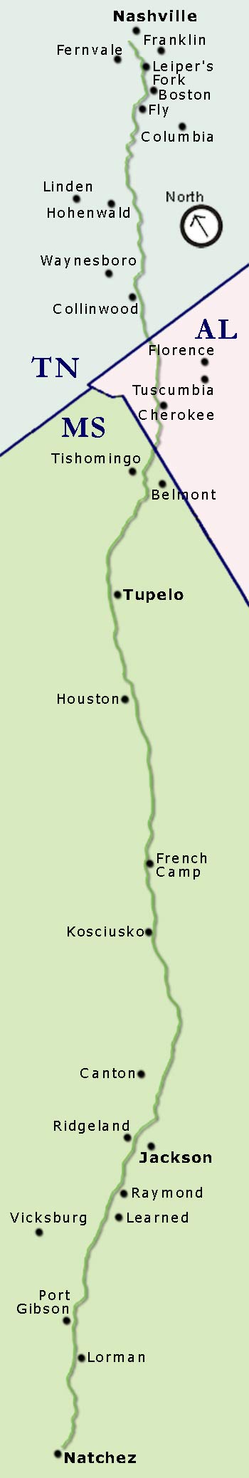
The Natchez Trace Parkway bicycle route spans 444 miles between Natchez, Mississippi and Nashville, Tennessee.


See more cycling the Natchez Trace photos - click here.
-
National Park Service designates the entire parkway as a bike route.
Numerous signs instruct cars to share the road with bicycles. - Commercial traffic is prohibited.
- Maximum speed limit for vehicles is 50 mph.
- Motorized traffic is generally very light except around Tupelo and Jackson.
-
No stop signs or stop lights.
Access on and off the Trace is via on/off ramps which means no need to worry about cross traffic. -
Scenery is awesome.
Instead of utility poles and buildings, the Trace is lined with forests, farmland, creeks and beautiful vistas. - All along the Trace historical and nature attractions offer interesting breaks and rest stops.
- Restroom facilities on the Trace are available about every twenty to thirty miles.
- Numerous side trails take you past antebellum and victorian homes, sunken roads, civil war battlefields and southern towns.
- There are many "cycling friendly" B&Bs, Guest Houses and Cottages located along and near the Trace.
Natchez Trace Parkway Road Rehabilitation and Paving Project
August 16, 2023:
A section of the Parkway south of Tupelo, MS closed for road rehabilitation and paving between milepost 239.2 (intersection with MS Hwy 32) and milepost 256.9 (intersection with MS 6/US 278).
Update on December 14, 2023:
The closed section of the Parkway, from milepost 239.2 to milepost 256.9, has reopened to traffic.
Travelers should expect single-lane closures into Summer 2024. Work continues to add an additional layer of asphalt, add permanent striping, and grade the shoulder.
My (Randy Fought at NatchezTraceTravel.com) educated guess is that only a couple miles or less of the 17 miles will be single-lane at any given time. When cycling always wear brightly colored clothing and have both front and rear flashing lights on your bicycle.
Looking to take a Self Guided Bike Trip on the Natchez Trace?
- NEW - Information and guidance rich, online Biking the Natchez Trace Itineraries that include RidewithGPS routes chock full of Points of Interest and Direction/Alert Cues - for FREE!
- Biking the length of the Parkway? - We have 18 different itineraries (9 biking North to South and 9 biking South to North) ranging from 4 days to 14 days. - click here!
- Want to bike a section of the Parkway "Out and Back"? - We have dozens of itineraries ranging from 2 days to 9 days in length. - click here!
- Tips are Appreciated!
Looking for a Fully Supported Bike Trip?
- See our tour guides info.
For more information about Biking the Natchez Trace, click on these links:
- Biking the Natchez Trace FREE Itinerary Planner
- Biking the Natchez Trace Parkway Photo Gallery
- Cyclist Reviews and Comments
- Biking the Natchez Trace Parkway YouTube Videos
- Drinking Water and Markets
-
Safety Rules and Recommendations
(including the heavy vehicle traffic areas in Tupelo and Jackson) - Out and Back Natchez Trace Bike Trips
- Trace/off-Trace loop routes:
Tennessee | Mississippi - Bicycle Repair Stations on the Natchez Trace Parkway
- Bike Shops near the Natchez Trace Parkway
- Natchez Trace Bike Tour Guides
- Tanglefoot Trail® rails to trails route from Houston, MS to New Albany, MS
- Weather on the Natchez Trace Parkway
- Natchez Trace Parkway Biking Tips
- Shuttle Services for cyclists and their bikes
- Public Transportation near the Natchez Trace Parkway
- Cycling Friendly B&Bs, Guest Houses, Vacation Rentals and Cottages located adjacent and near the Parkway
Click on their "Cyclist Info" tab for Bicycle Amenities and Map/Directions from the Natchez Trace - Camping along the Parkway
After you finish Biking the Natchez Trace:
Enjoy all this great info and advice?
Brag a little! I (or We) Biked the Trace - Stickers, Mugs and Clothing

We (two men) Biked - Coffee Mug

We (one woman and one man) Biked - Essential T-Shirt

We (two women) Biked - Coffee Mug

I (one man) Biked - Lightweight-Hoodie

We (one woman and one man) Biked - Sticker

I (one woman) Biked - Coffee Mug

We (two women) Biked - Sticker

We (two women) Biked - T-Shirt

I (one man) Biked - Coffee Mug

I (one woman) Biked - Sticker

We (two men) Biked - Tri-Blend T-Shirt

I (one woman) Biked - Throw Pillow

I (one man) Biked - Sticker

I (one man) Biked - Tri-Blend T-Shirt

We (two women) Biked - Premium Scoop T-Shirt
We (two men) Biked - Sticker

We (one woman and one man) Biked - Classic T-Shirt