Phosphate Mine is located on the Natchez Trace Parkway at milepost 390.7.

Phosphate Mine - Natchez Trace Parkway

Photo Credit: Steven Markos - National Park Planner
Scroll down the page to view more pictures!

From here north for approximately 40 miles the parkway passes through or near a geologic region of limestone rich in phosphate deposits.

Abandoned mine shafts in limestone ledges on both sides of the parkway in this immediate area are silent reminders of past mining activity.

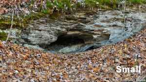
A 5-minute walk to your right leads to an abandoned railroad bed and a collapsed mineshaft in a limestone outcrop.

Phosphate Mine Photo Gallery
More info about Phosphate Mine and similar sites.
  • Click for a Location Map
  • Latitude: 35.568720
    Longitude: -87.431079
    Elevation (approximate): 692 feet
    Milepost: 390.7
Next stop to the South Next stop to the North

Natchez Trace Travel: Home - Facebook - Instagram - Merchandise

Back to Top